LAB 5: Final Project
Goal: The objective for the final lab was to develop our own spatial question and answer it by creating a visual representation using ArcMap. In order to create a spatial representation answering our question it was necessary to incorporate the use of at least four tools, with three of them being different.
Background: The spatial question had to be simple, relevant and also restricted to one specific county. To accommodate these requirements I decided to answer the question of where is the best place to build a cabin in Vilas County. In addition to this question I set specific restrictions. For instance the building of my cabin much be within a half mile of a lake. Although there are many lakes in Vilas County it is important that I build extremely close in proximity to a lake. Another requirement was the population of the area in which I plan to build my cabin. I chose to set a limit of a population less 1200 people. Building in a low populated area allows for me to maintain solitude at my cabin. Furthermore it is important to build within a reasonable distance away from a hospital. I chose to build in an area that is no more than 30 miles away from the only hospital in Vilas County. This is specifically important to prepare for possible emergency situations. My final requirement was to build within at least 10 miles from recreation areas such as parks, or golf courses. Having a cabin within a close distance of recreation areas provides several options for different activities around the cabin. Setting these requirements sets up a specific area that accommodates my need to be near water, maintain solitude in a small population, have access to a hospital in case of emergencies, and have different options for recreation.
Method: To answer my question amongst my restrictions I had to develop a visual representation illustrating the best possible areas to build my cabin. To determine this specific area I had to first set my limit of Vilas County. To do this I added the US counties to my layout and specifically selected Vilas County. After I had Vilas County selected I could then make it its own layer that I could continue to work off of.
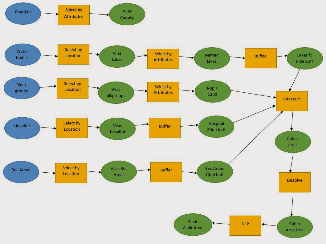
After I had my Vilas County limit I then had to address my first requirement of building within a half mile of a lake. To do this I had to add lakes in Vilas County. I then used the DNR data and inserted US water bodies. Once I added all the US water bodies I then had to select the ones located specifically within Vilas County. After selecting all water bodies by location that lay within Vilas County I made another selection by attributes selecting only the water bodies that are only named lakes/ponds. I created a layer from this selection showing only the named lakes and ponds within Vilas County. Then I had to address my requirement of building within a half mile a lake. To do this I created a buffer around each lake representing a half mile.
Now that I created my half mile buffer around the Vilas County lakes I could then move on to my next restriction of building in areas with a population less than 1200. To accomplish this I created a layer of the Vilas County block groups from the US census data. After I had the block group layer I then selected all the block groups with populations less than 1200 and made that its own layer. By doing this I established the all the areas that met my population requirement.
The next restriction I set was to build within at least thirty miles of a hospital. To portray areas within this 30 mile restriction I first had to add the only hospital in Vilas County. After I added the hospital I then added the thirty mile buffer surrounding the hospital. By adding this buffer I was able to illustrate the areas that were within this specific proximity of the hospital.
The final requirement that I wanted to meet for building my cabin was to be in within a close distance to recreation areas. To do this I created a layer of the recreation points within Vilas County. I chose to put a 10 mile buffer around these points which allows for several recreational options within a reasonable distance from the cabin. After the buffer was added I finished representing each individual requirement. However, I needed to portray an area that satisfied all four of these requirements at one time.
To create most suitable area to build a cabin following all these restrictions I had to produce a layer showing where all four requirements overlapped. In order to create this layer I was ran an intersect tool on the half mile lake buffer, the block groups with population less than 1200, the 30 mile hospital buffer, and 10 mile recreation area buffer. This created a layer which showed the suitable area to build in accordance to all these requirements. To better illustrate this I then clipped this new layer to only show the areas within Vilas County. Finally I dissolved to the intersected clipped area to produce one clear solid area portraying the best locations to build my cabin.
Results:

Evaluation: In comparison to other Labs this one was far more challenging considering I had to develop my own spatial question and answer this. Because I was required to develop my own question I also had to develop my own step by step process to answer it, which was provided for me in previous labs. Despite the fact this lab was much more challenging I feel as though I was able to grasp a better understanding of GIS. By being forced to essentially create my own question, instructions, and process I was forced to problem solve. This problem solving was key to increase my knowledge and ability to develop and answer real life spatial questions.
Sources:
ESRI2013 US Census Data
ESRI2013 US Data
WiDNR2014 Data
No comments:
Post a Comment