Thursday, May 14, 2015

THE LAST ONE!!

Temperature: 59
Real Feel: 59
Wind: SE 13 mph 
Precipitation: 0%
Humidity: 48%

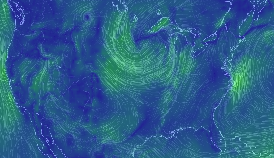
Today thus far has been very similar to the previous day as I had anticipated. I had anticipated that high pressure would last throughout most of the day and begin to die down, which appears to be true now that cloud cover and winds are much more significant later in the afternoon. In addition to the decrease in pressure, cloud cover has increased considering that moist air from the south has, as I predicted, made its way north. Although there hasn't been any rain thus far today, my prediction for it to occur sometime tonight still seem very possible.

Moist Air Today Providing Fuel For
Rain - Still More to Come
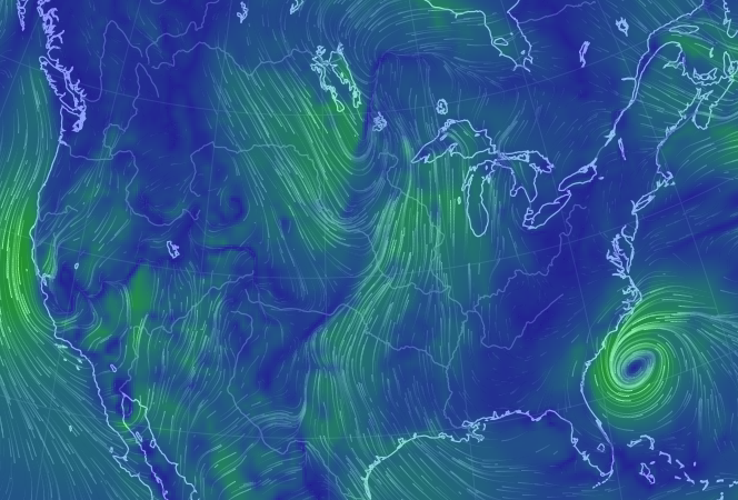
For the greater part of the day, the skies have been overcast with what look like stratocumulus cloud cover. The increase in cloud cover today compared to yesterday is strongly related to the decrease in pressure and increase in water vapor. The moist air that was to the south yesterday has appeared to have made its way to Wisconsin creating overcast skies. Not only has the moist air contributed to overcast skies, but it also has increased the possibility for rain sometime later today. With the south east winds created by the high pressure areas now to the east, chances of precipitation are very possible within the next several hours. Not only are conditions cloudy and likely going to be rainy, temperatures are still considerably cool as the effects from a cold front are still apparent. However, I don't expect the cool temperatures to continue for much longer.

High Pressure Has Moved East, Meaning
More Clouds and Winds Today
South East Winds in Combination With
Cloud Cover May Mean Rain

There Is The Rain!
Despite the fact I've been predicting temperatures to increase over the last couple of days, which they haven't, I am more confident in my prediction for warmer weather tomorrow. There is no longer any presence of a cold front affecting the Wisconsin area and with the continuation of southern winds and the current position of the jet stream, placing Wisconsin in a ridge, temperatures will definitely begin to increase. Although temperatures will likely increase the next few days high chances for precipitation remain likely as significant amounts water vapor continues to makes its way north.
Jet Stream Bringing in Warmer Air
For Temperature Increase Tomorrow


Wednesday, May 13, 2015

Wednesday, May 13th, 2015

Temperature: 58
Real Feel: 58
Wind: SE 10 mph 
Precipitation: 0%
Humidity: 37%

Because of the high pressure to the north from yesterday I was accurate in predicting that skies would be fairly clear today. I also predicted that today would begin to warm up as the cold front has died out. In addition to the end of the cold front Wisconsin is no longer positioned within a jet stream trough which was feeding in polar continental air to the area. Although today has not had a dramatic increase in temperatures thus far, I am still anticipating a greater increase within the next couple of days.

Jet Stream Positions Wisconsin Within
a Ridge - Warmer Temps to Come
Although this morning started out with overcast altostratus skies, cloud cover has significantly decrease into this afternoon. There are minimal alto cumulus clouds remaining in the sky due to the presence of high pressure over Wisconsin. In addition to clear skies the high pressure in contributing to mild south east winds. Although the winds are south east the high pressure and lack of cloud cover will prevent any significant chance for precipitation today. Furthermore the jet stream has shifted and has positioned Wisconsin in a slight high pressure ridge thus creating the means for temperatures to warm dramatically. Despite the high 50 degrees right now, I expect a conditions to warm a considerable amount within the  next several days.
High Pressure Allows Cloudy Skies to Clear
As south east winds continue to last into tomorrow and high pressure begins to die down, I expect a slight possibility for rain tomorrow in relation to large amounts of moist air to the south moving north. However, the chance for rain will likely not occur until later tomorrow evening or possibly into the following day as high pressure continues to prevail. Overall I expect tomorrow to be similar today in regards to cloud cover and temperature but begin to change into the evening as the chance for rain increases.

Moist Air to the South Moving North
 

Tuesday, May 12, 2015

Its Cold But The Semester Is Almost Over!

Temperature: 51
Real Feel: 51
Wind: NNE 11 mph 
Precipitation: 0%
Humidity: 41%

Because of a recent cold front, low pressure and a jet stream trough I predicted conditions to remain cool and cloudy. Unfortunately those factors leading to my prediction of another cold cloudy day were accurate. I also mentioned that I did not expect there to be a significant chance for any precipitation considering the cold temperatures along with a lack of water vapor, however I was not completely right in mentioning this as there was a brief light rain this morning.

Air Is Still Pretty Dry
Today has been another cold and miserable spring day. This morning started out with full overcast skies and a light but cold rain. Throughout the day cloud cover remained fairly consistent as the sun was only present for brief periods throughout the day. In addition to the clouds and the cold, contributed by yet another cold front that has come through from the north, a high pressure system also to the north is creating north eastern winds in Eau Claire. Even though winds have a slight eastern direction there is minimal amounts of water vapor considering the cold 50 degree temperatures so more precipitation for today is unlikely.

Another Cold Front and Some High Pressure
I am expecting that tomorrow will begin a pattern that will bring us back into spring conditions. With high pressure to the north, cloud cover will likely clear up and the sun will be more apparent for tomorrow. Also the jet stream appears to have shifted into a more zonal flow, taking Eau Claire out of that cold trough and may possibly position us within a ridge which will allow temperatures to increase. I still do not expect a great chance for rain tomorrow as long as the air continues to remain fairly dry.
Zonal Jet Stream Removing Wisconsin From
Its Position Withing a Cold Trough


Monday, May 11, 2015

Why Is It So Cold?

Temperature: 61
Real Feel: 61
Wind: SW 13 mph 
Precipitation: 0%
Humidity: 47%

Today has been fairly cool and cloudy with stratus overcast skies. Because of significant low pressure over Eau Claire conditions are considerably cloudy and windy. As high pressure to the west and south west flow towards the low pressure in the area, strong south west winds are extremely apparent. In addition to low pressure contributing to cool and cloudy conditions, a cold front is further contributing to colder temperatures along with Eau Claire's position within a jet stream trough. Polar continental air is affecting the area despite southern winds. Even though there is significant low pressure and full overcast skies, there is little water vapor in the air making precipitation unlikely for today. Furthermore occluded front where the cold and stationary front meet indicate that the system is beginning to die out and severe weather is not likely to occur.

Significant Low Pressure and Cold Front
Causing Cold and Cloudy Conditions
Temperatures Considerably Cold
For May Weather
Strong Winds Flowing Towards
Low Pressure
Dry Air Preventing Chance For Rain Today
 \Tomorrow may be just as cool as today if not colder. Even though the cold front begins to die down its effects will still last throughout tomorrow. Also, as Wisconsin sits within a jet stream trough, cold air to the north will continue to cool the Eau Claire. In addition to a continuation of cold temperatures I expect that the skies will remain cloudy tomorrow as pressure remains low. I don't expect conditions to return back to spring type weather until further into the week when low pressure dies out and the jet stream shifts taking us out of that trough.
Eau Claire Stuck on the Edge of a Jet
Stream Trough - Bringing Down Cold Air


Cold and Dreary Mother's Day

Saturday:
Like I predicted, Saturday was considerably warm and sunny compared to Friday. Because pressure slightly increased skies were fairly clear for most of the day and temperatures rose to almost 70 degrees. The wind speeds were fairly low for majority of the day and despite the north east direction there was no rain considering the lack of cloud cover. However, north east wind prevailed allowing for a decrease in temperatures and a greater chance in precipitation for the following day.

Sunday:
Unfortunately weather conditions for mothers day were not as pleasant as they should have been. Temperatures decreased slightly from the previous day considering consistent north east winds and overcast skies were consistent throughout the day. Because of the significant amount of cloud cover and the north east winds precipitation was highly likely, and thus there was an occurrence of some mild storms and heavy rainfall Sunday night.

Friday, May 8, 2015

First Hurricane of the Year!

Temperature: 59
Real Feel: 59
Wind: WNW 9 mph 
Precipitation: 0%
Humidity: 59%

Everything I anticipated to happen for today has happened. Temperatures have significantly decreased because of the incoming cold front from the west. When the cold front made its way through it produced some mild thunderstorms last night as it contrasted with the very warm moist air from yesterday. I watched as last evening cumulus clouds continued to gain vertical growth, and several hours after storms were initiated. The cold front also brought a couple low pressure system towards the Wisconsin area in addition to cooler temperatures. Because of the low pressure skies are mostly cloudy and winds are moderately strong just as I had predicted.

Major Decrease in Temperatures!
Temperatures have decreased a considerable amount today compared to yesterday by almost 20 degrees due to the cold front. Also skies are overcast, covered by full stratus clouds considering the surrounding low pressure systems to both the north and south of Wisconsin. Low pressure has also allowed for winds to pick up as well as shift direction. Winds are now coming from the north west as a high pressure area towards to west is contributing to a rapid flow of air towards the lower pressure in the area. Precipitation for today does not seem likely as temperatures have decrease and the air is now considerably dry.  

Cold Front and Surrounding Low Pressure
Creating a Cool Cloudy Day in Wisconsin
Cool Temperatures to the West
of Cold Front
Considerably Dry Air Coming
With Colder Temperatures
Tomorrow will hopefully warm up slightly as the effects of the cold front die down. As long as Wisconsin sits within a jet stream ridge temperatures will only cool down for a short period of time. Also I expect cloud cover for tomorrow will be much less as high pressure makes its way to the low pressure areas that are currently affecting us. Overall I anticipate a fairly warm sunny day for tomorrow with little chance of rain due a possible increase in pressure and dry air. Further on in the week temperatures may increase even more as well as an increase in the possibility for storms because of hurricane Ana heading for the Carolinas. The hurricane will likely bring very very warm moist air to many areas allowing for large chances of storms and hot humid weather.
Jet Stream Flow Still Keeping Temperatures
Moderately Warm
 
Mild Hurricane Ana Likely to Bring Warm
Moist Air to Many Places


Thursday, May 7, 2015

No Storm Yesterday.. But There Is Hope For Today

Temperature: 79
Real Feel: 79
Wind: S 18 mph 
Precipitation: 0%
Humidity: 43%

I mentioned the possibility for more storms to occur today. Although nothing has happened throughout the morning into the afternoon, it appears that my prediction may soon become accurate. Although I still waiting to determine whether or not my storm prediction was accurate, I can conclude that I was not right in assuming the warm front to the south would affect Wisconsin. The front has appeared to die out as of today, and the major contribution to warm temperatures has been consistent south winds along with a high pressure jet stream ridge.


Consistent Meridional Jet Stream - Putting
Wisconsin In a Warm Ridge
This morning once again started out fairly sunny with only a few cirrus clouds. However, as the day soon progressed into the after cloud cover thickened and the skies are not covered with cumulus congestus type clouds, which possibly identify some incoming storms. In addition to the growing cumulus clouds a low pressure system off to the north west will allow for even more potential for storms. Because of the low pressure to the north west and high pressure to the south east, Wisconsin is being affected by very strong gust of south winds. If cloud cover and low pressure were not enough to create means for a storm, an incoming cold front to the west will likely contrast to the warm moist air that we have been experiencing the last few days. As the cold front makes its way over with low pressure, warm moist air will be uplifted causing already cumulus congestus clouds to gain even more vertical growth and wind speeds will likely become even stronger. With all the current variables, storms at this point seem inevitable for sometime this evening.


Incoming Cold Front and Low Pressure
Making Storms Very Possible
Warm Temperatures Contrast With
Incoming Cold Front
Dew Point Very Close to Temperature
Confirming Moist Air
Strong Gusts of South Winds
For tomorrow I expect temperatures to cool down a little bit as the cold front makes its way over Wisconsin. Despite a slight decrease in temperature I do not expect anything dramatic considering we are still sitting within a consistent high pressure ridge. With oncoming low pressure as well, winds may be slightly more significant and skies will likely be moderately cloudy.