Real Feel: 61
Wind: SW 13 mph
Precipitation: 0%
Humidity: 47%
Today has been fairly cool and cloudy with stratus overcast skies. Because of significant low pressure over Eau Claire conditions are considerably cloudy and windy. As high pressure to the west and south west flow towards the low pressure in the area, strong south west winds are extremely apparent. In addition to low pressure contributing to cool and cloudy conditions, a cold front is further contributing to colder temperatures along with Eau Claire's position within a jet stream trough. Polar continental air is affecting the area despite southern winds. Even though there is significant low pressure and full overcast skies, there is little water vapor in the air making precipitation unlikely for today. Furthermore occluded front where the cold and stationary front meet indicate that the system is beginning to die out and severe weather is not likely to occur.
\Tomorrow may be just as cool as today if not colder. Even though the cold front begins to die down its effects will still last throughout tomorrow. Also, as Wisconsin sits within a jet stream trough, cold air to the north will continue to cool the Eau Claire. In addition to a continuation of cold temperatures I expect that the skies will remain cloudy tomorrow as pressure remains low. I don't expect conditions to return back to spring type weather until further into the week when low pressure dies out and the jet stream shifts taking us out of that trough.
Today has been fairly cool and cloudy with stratus overcast skies. Because of significant low pressure over Eau Claire conditions are considerably cloudy and windy. As high pressure to the west and south west flow towards the low pressure in the area, strong south west winds are extremely apparent. In addition to low pressure contributing to cool and cloudy conditions, a cold front is further contributing to colder temperatures along with Eau Claire's position within a jet stream trough. Polar continental air is affecting the area despite southern winds. Even though there is significant low pressure and full overcast skies, there is little water vapor in the air making precipitation unlikely for today. Furthermore occluded front where the cold and stationary front meet indicate that the system is beginning to die out and severe weather is not likely to occur.
 |
| Significant Low Pressure and Cold Front Causing Cold and Cloudy Conditions |
 |
| Temperatures Considerably Cold For May Weather |
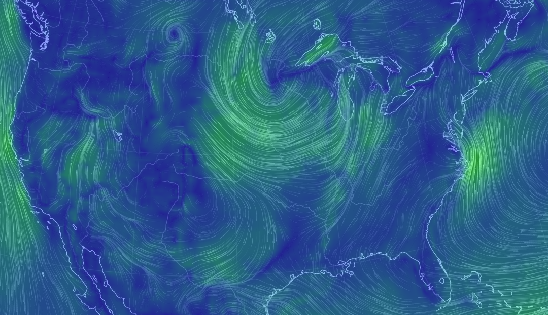 |
| Strong Winds Flowing Towards Low Pressure |
 |
| Dry Air Preventing Chance For Rain Today |
 |
| Eau Claire Stuck on the Edge of a Jet Stream Trough - Bringing Down Cold Air |
No comments:
Post a Comment